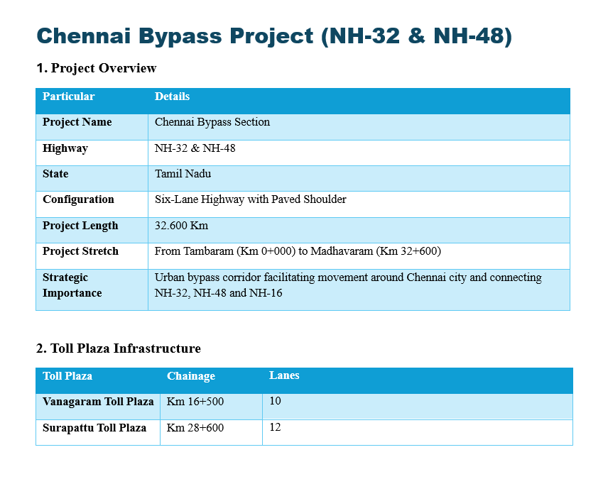
The Chennai Bypass Project, officially designated as the Chennai Bypass Section, is a vital infrastructure development located in Tamil Nadu. Configured as a six-lane highway with a paved shoulder, this roadway operates across NH-32 and NH-48. The total project length spans exactly 32.600 kilometers, establishing a high-capacity regional transit route. This specific stretch begins at Tambaram (Km 0+000) and extends seamlessly to its endpoint at Madhavaram (Km 32+600).
Strategically, this highway serves as an essential urban bypass corridor. Its primary function is facilitating continuous movement around Chennai city, effectively alleviating internal urban congestion. By acting as a critical geographic link, the bypass connects three major national highways: NH-32, NH-48, and NH-16. This robust connectivity streamlines local logistics and regional transit networks, allowing freight transports and long-distance travelers to bypass the metropolitan center efficiently.
To manage traffic flow effectively, the project incorporates necessary toll plaza infrastructure across two primary locations. The Vanagaram Toll Plaza, situated at chainage Km 16+500, is equipped with a 10-lane setup. Further along the stretch is the Surapattu Toll Plaza, located at chainage Km 28+600, featuring a 12-lane configuration. These facilities ensure smooth processing across this crucial corridor.